With a wind vane we measure the direction of the wind. To indicate the direction we use a compass rose.
On weather maps, we indicate the direction of the wind with an arrow. The point of the arrow to where it is going.
In the weather reports, we indicate the origin of the wind, where it comes from.
Example: a wind "said" from the South-West (220 °), blows towards the North-East (40 °)
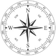
With an anemometer, we measure the wind speed which is given in Knots or Km / h 1 kt = 1.852 Km / h The Beaufort scale corresponds to a sea state associated with a “range” of the mean wind speed. (not very precise) The Fungir displays the wind speed, only in knots, km / h and miles which are much more precise units of measurement.
| Force | Nom | Vitesse en nœuds | Effets sur la mer |
|---|---|---|---|
| 0 | Calme | moins de 1 | Miroir |
| 1 | Très légère brise | 1 à 3 | Quelques rides |
| 2 | Légère brise | 4 à 6 | Vaguelettes ne déferlant pas |
| 3 | Petite brise | 7 à 10 | Apparition de moutons |
| 4 | Jolie brise | 11 à 16 | Petites vagues, de nombreux moutons |
| 5 | Bonne brise | 17 à 21 | Vagues modérées, moutons, embruns |
| 6 | Vent frais | 22 à 27 | Crêtes d'écumes blanches, lames, embruns |
| 7 | Grand frais | 28 à 33 | Trainées d'écumes, lames déferlantes |
| 8 | Coup de vent | 34 à 40 | Tourbillons d'écumes à la crête des lames, trainées d'écumes |
| 9 | Fort coup de vent | 41 à 47 | Lames déferlantes grosses à énormes, visibilité réduite par les embruns |
| 10 | Tempête | 48 à 55 | Conditions exceptionnelles |
| 11 | Violente tempête | 56 à 63 | Conditions exceptionnelles |
| 12 | Ouragan | supérieur à 63 | Conditions exceptionnelles |
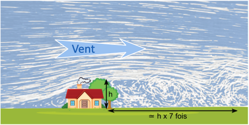
Depending on the force of the wind, an obstacle such as trees, buildings, a cliff or a dune can disturb the wind over 3 to 7 times its height. The wind is also disturbed before the obstacle but much less, about twice the height.
Often in summer, when it is hot, a thermal wind also called sea breeze or day breeze appears.
For this coastal wind to occur, some conditions must be met.
little wind during the day (less than 8 knots)
a sun that heats well
a fairly cool sea temperature
Here is the principle of operation.
During the day, the sun heats the surface of the earth much faster than the sea.
The warmer "lighter" air rises and creates a call for air.
The cooler air above the sea therefore moves to replace it.
A loop is thus put in place.
The formation of cumulus clouds above the land in the afternoon is a good sign on the presence of a thermal breeze otherwise watch your Fungir which gives the wind in real time on your spot.
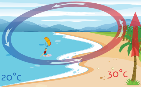
You should also be wary at the end of the day, because without the action of the sun the loop will stop or even reverse, creating an earth breeze.
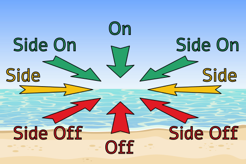
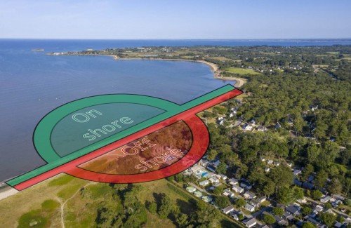
OFF SHORE
The “Off shore” wind is a wind that comes from the land and blows towards the sea, also called land wind. The danger is being blown off by the wind and not being able to get back to the beach. This is because the offshore wind direction does not allow you to reach an exit edge, unless you navigate efficiently upwind. Navigation is strongly discouraged.
ON SHORE
The “on shore” wind is a wind which comes from the sea and which blows towards the land, it can also be called sea wind. To navigate with an onshore wind, it is essential to know how to go upwind, at the risk of come back to the beach after his first edge.
SIDE
The “side” wind is a wind that blows parallel to the beach. It can also be called crosswind. The wind side is the safest direction to navigate. The edges are drawn perpendicular to the beach. Riders always have access to an exit edge, towards the beach. Be careful though, the wind can switch "Off Shore" very quickly without noticing.
On the Fungir, the small thumb up or down pictogram tells you at a glance if the live wind direction is good or not.
COPYRIGHT © TOUS DROITS RÉSERVÉS